Still in its nascency in the early 2000s, Geographic Information System (GIS) was quickly becoming an integral part of urban development projects. Everyone was taking great strides to use spatial tools for designing maps or performing analytics. However, when it came to applying this promising technology to a planner’s daily workflow, utilization was far from optimal. As a newly appointed urban planner for city and local governments in the Houston area, Suhag Kansara witnessed this first hand.
Kansara decided to ride the GIS wave and help fellow planners make proper use of these tools. He developed a business plan based on three basic principles: 1) designing automation tools that help planners solve the problems they face regularly, 2) simplifying complex procedures to improve project collaboration, and 3) helping facilitate processes to build sustainable cities. This led to the inception of
ViewPro, a company that automates map-based tools to support visualization, collaboration, and spatial analysis. The company partners with Esri, the worldwide leader in geospatial software, enabling ViewPro to customize and extend the reach of innovative Esri technology to local governments, cities, and municipalities.
In addition to bringing Esri’s products to customers, the company’s vision and founding principles are demonstrated through its three customizable solutions –
GeoZone,
GeoComment, and
GeoLocator.
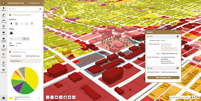
GeoZone automates the workflow associated with zoning requests, and provides stakeholders with in-depth understanding of the local zoning codes. It is a 3D-enabled map-based solution that is simple to use and designed around a planners’ daily workflow. With GeoZone, planners can easily visualize and analyze the development pipeline within a few clicks.
GeoComment enables city planners and municipalities to solve citizen engagement challenges by including hard-to-reach population groups, such as minorities andthe physically disabled. This tool enables more people to participate in the planning process. Additionally, city officials can listen to everyone within the community. Last but not least, ViewPro has developed GeoLocator, a solution that highlights properties and short lists sites based on their economic development potential. GeoLocator’s access to Esri’s Demographic and Business Analytics data helps clients identify the factors contributing to current local development trends – an important tool for a city’s economic development strategy.
“By using our solutions, planners and local government bodies are relieved from the burden of shifting through multiple data sources. They can also plug in different apps with it to bring efficiency into their workflow,” Kansara mentions. “Our products are cloud-based, easily accessible, and transparent enough to engage at every level of city governance. They can seamlessly address the different needs and requirements of our clients and provide the same level of experience to everyone in a cost- and time-effective way.” A big key to ViewPro’s success is their attention to customer requirements and feedback, which enables the company to enhance the capabilities of its solutions. “We always welcome new ideas to understand users’ needs and pain points,” Kansara highlights.
With these robust offerings, ViewPro has helped nearly 45 communities with their sustainable growthplanning initiatives and objectives. For instance, the company worked with the City of Richmond, TX, a city of more than 20,000 people in South Texas. The city government was striving to expand its local economic development options by attracting new businesses to the city and build strong community character to compete with nearby suburbs. Through a customized GeoZone and GeoLocator solution, the
City of Richmond addressed planning and administrative requirements, attracted investors, and demonstrated community strength with a single, unified GIS application.
These instances of client success are ViewPro’s impetus for growth. Looking ahead, ViewPro plans to combine their offerings with other ancillary Esri products, like ArcGIS Urban and ArcGIS Hub,to provide more comprehensive solutions to city clients, city planners, and economic development professionals. “In the last three years, our products have become an integral part of many city and state governments’ everyday operation. That’s why we did not need to scale back during the pandemic. In a nutshell, we have set out on the mission of solving planning challenges through the right use of GIS technology and will leave no stones unturned to achieve it,” Kansara concludes.